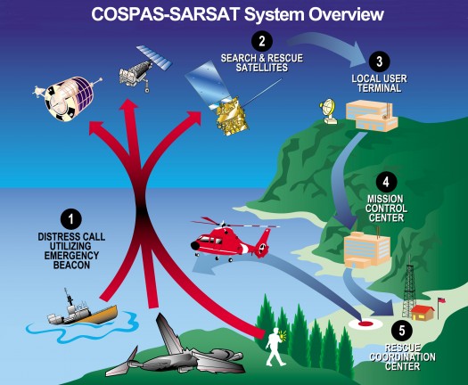
If a plane crashes in the woods and nobody hears it, does it make a sound? Never mind contemplating this scenario as a philosophical riddle. This can be a real life or death question. And the answer most of the time is that, even if no people are nearby, something is indeed listening high above. That something is a network of satellites orbiting about 450 miles overhead. The “sound” they hear isn’t the crash itself, but a distress signal from a radio beacon carried by many modern ships, aircraft, and even individual people venturing into remote wildernesses. In the last 25 years, more than 25,000 lives have been saved using the satellite response system called Search and Rescue Satellite-aided Tracking (SARSAT). So what are these life-saving superhero satellites? Why they are mild-mannered weather satellites. “These satellites do double duty,” says Mickey Fitzmaurice, a National Oceanic and Atmospheric Administration (NOAA) systems engineer for SARSAT. “Their primary purpose is to gather continuous weather data, of course. But while they’re up there, they might as well be listening for distress signals too.” In February, NASA launched the newest of these Polar-orbiting Operational Environmental Satellites (or POES) into orbit. This new satellite, called N-Prime at launch and now dubbed NOAA-19, prevents a gap in this satellite network as another, aging NOAA satellite reached the end of its operational life. “The launch of N-Prime was a big deal for us,” Fitzmaurice says. With N-Prime/NOAA-19 in place, there are now six satellites in this network. Amongst them, they pass over every place on Earth, on average, about once an hour. To pinpoint the location of an injured explorer, a sinking ship, or a downed plane, POES use the same Doppler effect that causes a car horn to sound higher-pitched when the car is moving toward you than it sounds after it passes by.
In a similar way, POES “hear” a higher frequency when they’re moving toward the source of the distress signal, and a lower frequency when they’ve already passed overhead. It takes only three distress-signal bursts — each about 50 seconds apart — to determine the source’s location. Complementing the POES are the Geostationary Operational Environmental Satellites (GOES), which, besides providing weather data, continuously monitor the Western Hemisphere for distress signals. Since their geostationary orbit leaves them motionless with respect to Earth below, there is no Doppler effect to pinpoint location. However, they do provide near instantaneous notification of distress signals.
In the future, the network will be expanded by putting receivers on new Global Positioning System (GPS) satellites, Fitzmaurice says. “We want to be able to locate you after just one burst.” With GPS, GOES will also be able to provide the location of the transmitter.
Philosophers beware: SARSAT is making “silent crashes” a thing of the past.
Download a two-page summary of NOAA-19 at www.osd.noaa.gov/POES/NOAA-NP_Fact_Sheet.pdf. The Space Place gives kids a chance to rescue stranded skiers using their emergency rescue beacons. The Wild Weather Adventure game awaits them at spaceplace.nasa.gov/en/kids/goes/wwa.

NOAA's polar-orbiting and geostationary satellites, along with Russia's Cospas spacecraft, are part of the sophisticated, international Search and Rescue Satellite-Aided Tracking System.
This article was provided by the Jet Propulsion Laboratory, California Institute of Technology, under a contract with the National Aeronautics and Space Administration.


